
Bethel ZIP Code Coverage at a Glance
The strongest official local finding is 06801, associated with the Bethel Post Office. Connecticut Secretary of the State post-office material also lists nearby Brookfield 06804 and Danbury 06810, but it does not provide a parcel polygon or a complete address list for the town. The ZIP code directory therefore needs an evidence label for each row. A postal association is not the same thing as a legal town line, a parcel record, or a person's residence.
| ZIP | Relationship to Bethel | Post office or postal city | Notes and evidence |
|---|---|---|---|
| 06801 | Primary Bethel postal coverage and Bethel postal city addresses | Bethel Post Office, Bethel, CT | SOTS names Bethel 06801; verify each address with USPS |
| 06810 | Secondary sources report possible service or polygon overlap near Bethel | Danbury, CT postal geography | Exact Bethel intersection is not confirmed by an official USPS or municipal address list |
| Other ZIPs | No other ZIP serving Bethel was located in the official SOTS post-office source | Not established | Do not add a nearby ZIP without an address-specific USPS result |
The official Connecticut post-office list is the local starting point, while the USPS ZIP Code Lookup is the operational check for a particular street address. A ZIP code directory can name 06801 as primary and can document the 06810 gap, but it should not turn an unconfirmed map result into a claim about Bethel's legal boundary.
Use USPS to Verify a Bethel ZIP Code
The USPS lookup is the best first check when the question is whether a mailing address is formatted and which postal ZIP is returned. It offers three modes. By Address takes a street and place. By City and State returns ZIP and community choices. Cities by ZIP Code works in the other direction. USPS explains that postal boundaries can differ from municipal boundaries, so the result should be saved with the full input and the date of the check.
The official USPS screen below is the source image for the three modes and their required fields.
Open the official USPS ZIP Code Lookup before standardizing a Bethel address.
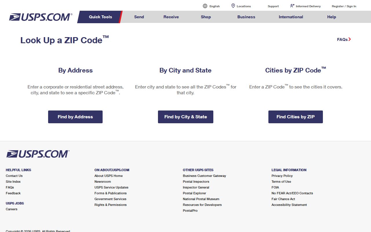
The screen shows postal search choices, not a resident record. A returned ZIP tells a carrier where the address is routed; it does not show who receives mail there.
| USPS mode | Fields | Required and optional details |
|---|---|---|
| By Address | Company; Street Address; Apt/Suite/Other; City; State; ZIP; Find | Street Address, City, and State are required. Company, unit, and ZIP are optional. |
| By City and State | City; State; Find | Returns the ZIP and community associations USPS has for that place. |
| Cities by ZIP Code | ZIP; Find | Returns the cities or communities associated with the entered five-digit ZIP. |
When more than one result appears, add a unit, directional, street suffix, or known ZIP. Keep the USPS result separate from the legal municipality returned by a parcel or town record. “Bethel, CT 06801” is a postal output; it is not a deed, tax card, or occupancy certificate.
Bethel 06801, 06810, and the Evidence Gap
Bethel's primary postal ZIP is 06801, and the local post office is the Bethel Post Office. Secondary ZIP-polygon sources commonly report 06810, the Danbury postal ZIP, in portions associated with Bethel. Research did not locate an official USPS or municipal polygon or address list that confirms the exact Bethel and 06810 intersection. That is an evidence gap, not a reason to choose one town line by guesswork.
USPS Postal Bulletin 22495 adds a dated routing clue. It documents a routing or container-label change from Danbury CT 06810 toward Bethel CT 06801 for a destination ZIP. The notice helps explain why postal labels and local maps may tell different stories, but it is not a current boundary file and does not identify every affected street.
For a current address, save the exact USPS return, then record the municipality from the Bethel Assessor, GIS, or Town Clerk separately. If a parcel carries Bethel as the legal town but a postal result points elsewhere, preserve both values and state which question each one answers. The postal crosswalk is strongest when the uncertainty is visible rather than hidden in a broad area label.
Finding Bethel Residents by ZIP Code
No official Bethel resident roll with a ZIP-only search field was located. The practical method is to turn a ZIP into a set of exact addresses, then use the local parcel and records systems for each address. The result is an address-based research set, not a claim that every person associated with a mailing line lives there.
- Normalize the address. Run the full street, unit, town, state, and optional ZIP through USPS. Save the returned postal form and the date.
- Check the legal parcel. Search IAS or Bethel GIS by street, owner, or parcel. Record the parcel ID, situs address, mailing line, and the card or layer date.
- Separate roles. Treat an owner, mailing recipient, business filer, court party, and occupant as different roles unless a separate source connects them.
- Refine civic geography. Use Bethel's street guide for side and range, district, representative, and polling-place information. It has no ZIP-only resident filter.
- Document the gap. If 06810 appears, cite the USPS result and note that official local coverage was not confirmed. Do not fill the gap with an unofficial people list.
Once a ZIP narrows the work to named streets, the Bethel street directory route supplies the more useful address chain. Keep the ZIP as one field in that chain, not as a substitute for a street number, parcel, or source date.
Bethel IAS Cards Show ZIP Without a ZIP Filter
The Bethel Assessor's IAS search does not expose a dedicated ZIP-only control in the captured form. Its search fields are Parcel ID, Alternate ID, Owner 1 Name, Street Number, and Street Name, with Search and Reset buttons. Search by one of those keys, then read the card's address, city, state, and ZIP. This route is useful when an exact address is known but it cannot produce a complete ZIP-wide resident list in one query.
The assessor screen below shows the local search fields used to reach a parcel card.
Open the official Bethel IAS parcel search to compare the live controls.
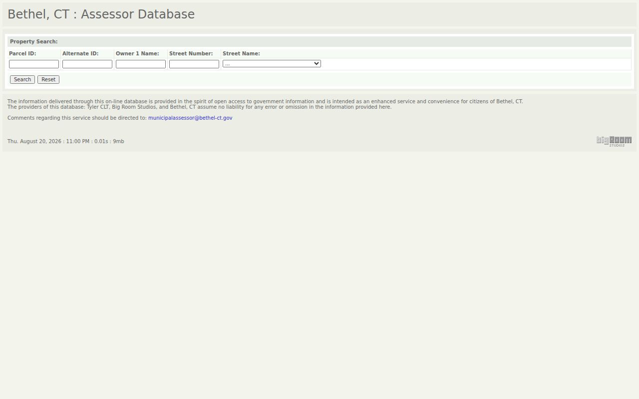
The image shows a parcel search, not a ZIP index. The card reached from the research sample at 31 Whippoorwill Road displays a Bethel 06801 address, parcel ID 32 47 083, and deed pointer Volume 1147, Page 826. The example anchors the ZIP to a parcel without making an occupancy claim.
IAS field cards can also show owner, mailing address, zoning, land use, acreage, sales history, building details, valuation, permits, and a sketch. The Town's last revaluation was 2022, with fair-market valuation scheduled for October 1, 2027. Date a card before comparing it with a later deed or a different ZIP return.
Bethel GIS Reads ZIP From Parcel Details
The Tighe & Bond Bethel GIS viewer also lacks a dedicated ZIP filter. Its search can match at least three characters in Parcel ID, owner, or street address. Parcel details and the public REST layer expose City, State, and Zip after a parcel is found. The viewer can export ZIP fields for selected abutters, but its result maximum was 1,000 and no pagination control was found.
The Bethel GIS viewer image below shows the map, parcel identify, search results, and local layer controls that connect a postal address to a parcel.
Open the official Bethel GIS viewer for the current parcel tools and layer dates.
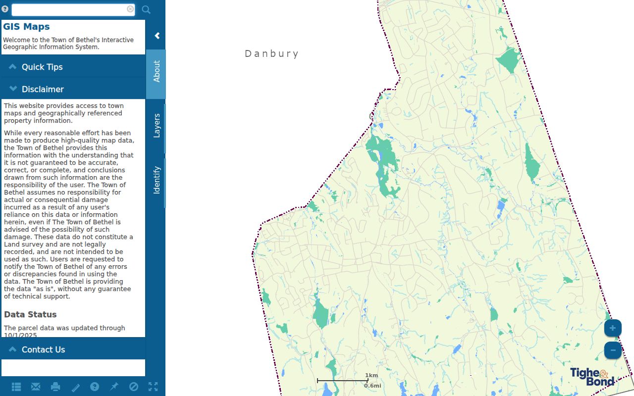
Parcel data on the Town route is dated 11/1/2024 and ownership data is dated 10/1/2024. Search results can show Parcel ID, Owner, and Address. Identify and Parcel Details can show mailing address, city, state, ZIP, lot size, and value. Abutter distances run from 5 feet through 500 feet, with PDF or CSV export for parcel, owner, mailing, address, and ZIP fields.
GIS is a spatial context tool, not a survey or legal boundary determination. A blank sale date or sale price stays blank even when a Book/Page is present. For ZIP work, that same discipline matters: read the field that the layer supplies, preserve its date, and do not turn a map result into proof that a person receives mail or occupies a parcel.
Bethel Voter Geography Is Finer Than a ZIP Code
The Bethel elections page points to the town registrars, polling districts, street guide, and Secretary of the State voter tool. The street guide uses side and number ranges to assign a Senate district, Representative district, voting district, and polling place. It has no ZIP field, yet it can be more precise for civic geography than a postal area.
Chestnut Street, Rockwell Road, and Walnut Hill Road are useful quality checks because their sides or number ranges cross district lines. A ZIP result may group them together while the street guide separates them. The guide is an address parser, not a list of voter names. The individual voter lookup has a separate public-data route, and the statewide file has fee and permitted-use limits.
Use the civic result to answer where an address votes, not who lives there. A district label can confirm that a street number has been interpreted correctly, but it cannot replace the parcel, deed, or a lawful person-specific record.
Bethel Routes, Districts, and Dated Population
Postal labels make more sense when the town's physical setting stays in view. Bethel sits in northern Fairfield County along routes 6, 53, and 58 and I-84, adjoining Redding, Danbury, Brookfield, and Newtown. The Town's facts material treats downtown and the Route 6 corridor as distinct research zones. A postal directory that flattens both into one area can miss why a street, parcel, business filing, or civic district looks different from a nearby address.
The Census QuickFacts estimate for Bethel was 21,682 people on July 1, 2025, compared with 20,381 on April 1, 2020. The same source lists 7,782 households and 2.64 persons per household. Those figures describe a dated population context, not a resident roster. Keep the date beside every number because a later estimate, revaluation cycle, or postal source may use a different snapshot.
For a local crosswalk, save four separate clues: postal ZIP, street and unit, parcel municipality, and civic district. Routes and town neighbors help explain the geography, but only the address-level sources decide the record path.
Bethel ZIP Code Boundaries and Town Limits
A postal ZIP is a delivery construct. Bethel's legal town line comes from municipal and parcel records, while USPS assigns a postal city and route for delivery. The two can disagree. A Bethel ZIP guide should show both values when they differ and say which source supplied each one. The 06801 finding is official at the post-office association level; the exact 06810 overlap remains unconfirmed in official local sources.
- ZIP versus ZIP+4
- A five-digit ZIP identifies a broad postal delivery area. ZIP+4 adds four digits for a tighter delivery segment, such as a block, building, or route detail.
- PO-box ZIP
- A postal ZIP assigned for delivery to post-office boxes. It does not, by itself, describe the legal location of a private parcel.
- Unique ZIP
- A ZIP assigned to one organization, facility, or other single delivery destination rather than a broad set of households.
- Carrier route
- The local delivery path used to sort and carry mail. It is finer than a town label and is not a property boundary.
When a result carries a nearby postal city, check the exact street and unit with USPS, then compare the parcel municipality in IAS or GIS. Keep the postal result, the parcel result, and any court or civic result as separate fields. That method prevents a ZIP guide from presenting postal convenience as legal proof.
What a Bethel ZIP Code Directory Cannot Prove
A USPS result confirms a delivery association, not that a named person receives mail or lives at the address. An IAS card can show an owner and mailing line, yet the assessor cautions that the card is not a deed certification or occupancy confirmation. GIS can add parcel, owner, mailing, and ZIP fields, but its ownership snapshot is dated. A blank or stale field is a reason to verify, not a reason to fill in a guess.
The local court property search accepts an optional full five-digit ZIP, but it is limited to its listed case categories and date coverage. Business.CT.gov and eLicense show registered entity or credential addresses, not a household roll. Voter data has its own access and privacy rules. These distinctions matter when a postal directory is used for family history, civic research, a property question, or a public filing check.
Postal boundary check. Treat a ZIP as one address clue. Verify the street, parcel municipality, source date, and lawful purpose before connecting a postal result to a person.
Use the smallest necessary set of fields, cite the official source, and keep uncertainty visible. A returned ZIP, a parcel snapshot, and a certified municipal record carry different weight. The best Bethel ZIP code directory entry is therefore a dated crosswalk, not a claim that postal geography reveals every household in town.