
Bethel Neighbors by Block
A Bethel block is easiest to study one source at a time. The Tighe & Bond parcel viewer can show the parcels beside a selected address, while the Bethel Assessor card adds owner, mailing, value, building, and deed-pointer fields. The official street guide supplies side and number ranges for a voting district. SOTS voter data has a separate release path. Planning files, library material, and public civic contacts add context, but none is a live list of every person near a home. Use the layer that answers the question, record its date, and do not turn an owner field into an occupant claim.
| Source | What It Shows About a Block | Access |
|---|---|---|
| Tighe & Bond Bethel GIS | Selected parcels, owners, mailing fields, and addresses within a chosen abutter distance. | Public viewer, with PDF/CSV export; ownership snapshot dated 10/1/2024. |
| GIS REST layer | Parcel ID, Feature Type, book/page, owner, mailing address, and sale fields. | Public query layer; classify the feature before treating it as a residence. |
| Bethel IAS field cards | Owner, mailing and situs lines, valuation, deed pointer, sales, permits, and building facts. | Public search by parcel, alternate ID, owner, street number, or street name; not an occupant list. |
| Bethel street guide | Side and number ranges tied to voting district and polling place. | Public PDF; it has no voter names or ballot choices. |
| SOTS voter file | Registry name, address, district, party, and election-history fields where law allows. | $300 CSV route with permitted-use certification; protected voters may be omitted. |
| Planning and Zoning | Address-linked applications, plans, comments, decisions, and neighboring-owner notices. | Current individual pages; retention and access limits depend on the custodian. |
| Library and directories | Historical block occupants, businesses, street order, and local-history leads. | Library, licensed, or in-person access; publication-year evidence, not current status. |
| Chamber and civic contacts | Public organization and business contacts that can add community context. | Public umbrella only; no member or home-address directory is assumed. |
Read the rows as layers, not as a combined list. A GIS or IAS row is an official snapshot. A Town Clerk deed or certified copy is the stronger title record. A library directory is tied to its publication year. The Chamber can help locate a public organization, but its business or community umbrella is not a resident or home-address roster. These distinctions keep Bethel neighbor research useful without overstating what a record can show.
Mapping Bethel Neighbors from a Parcel
Start with a single street address and keep four fields apart: situs, mailing address, legal description, and postal ZIP. USPS can standardize the address, but it cannot prove that a person lives there. In the Tighe & Bond viewer, an address search needs at least three characters and can match the parcel street field. Once the parcel is found, use the abutter tools, then cross-check the result with IAS and the Town Clerk.
- Enter the normalized street number and name, and note any unit designation and ZIP.
- Search Bethel GIS by address, then save the Parcel ID, address, owner, mailing fields, and data date.
- Select
AdjacentorFind Abutters, choose a 5- to 500-foot buffer, and useAdd ParcelorRemove Parcelto shape the set. - Open each nearby parcel and inspect its Feature Type before counting it as a neighboring residence or lot.
- Open IAS by Parcel ID, Alternate ID, Owner 1 Name, Street Number, or Street Name, and compare owner, mailing/situs, value, and deed pointer fields.
- Follow the Book/Page and legal owner names to SearchIQS or the Town Clerk, using an official copy when proof is needed.
Do not publish a bulk owner or mailing export just because the viewer can make one. Keep the source URL, inspection date, and reason for each field. That sequence creates a parcel-neighborhood view, not a people list. If the question expands from the near block to every number on one named road, use the Bethel street directory for the broader address chain and keep the same owner-versus-occupant caution.
Bethel Neighbors: 5-500 Feet
Bethel’s GIS viewer offers a useful numerical check on the word abutters. Abutter Distance can be set to 5, 50, 100, 200, 300, 400, or 500 feet. Adjacent and Find Abutters work from selected parcels, and Clear Abutters removes the set. Export Report and Print Labels can send Parcel ID, Owner, Mailing Address, City, State, ZIP, and Address to PDF or CSV. Add Parcel and Remove Parcel let you shape a small block set instead of accepting every nearby polygon.
The Bethel GIS viewer shows the controls used to select a parcel and find abutters. The linked screenshot is a tool reference, not a claim that the displayed set is current.
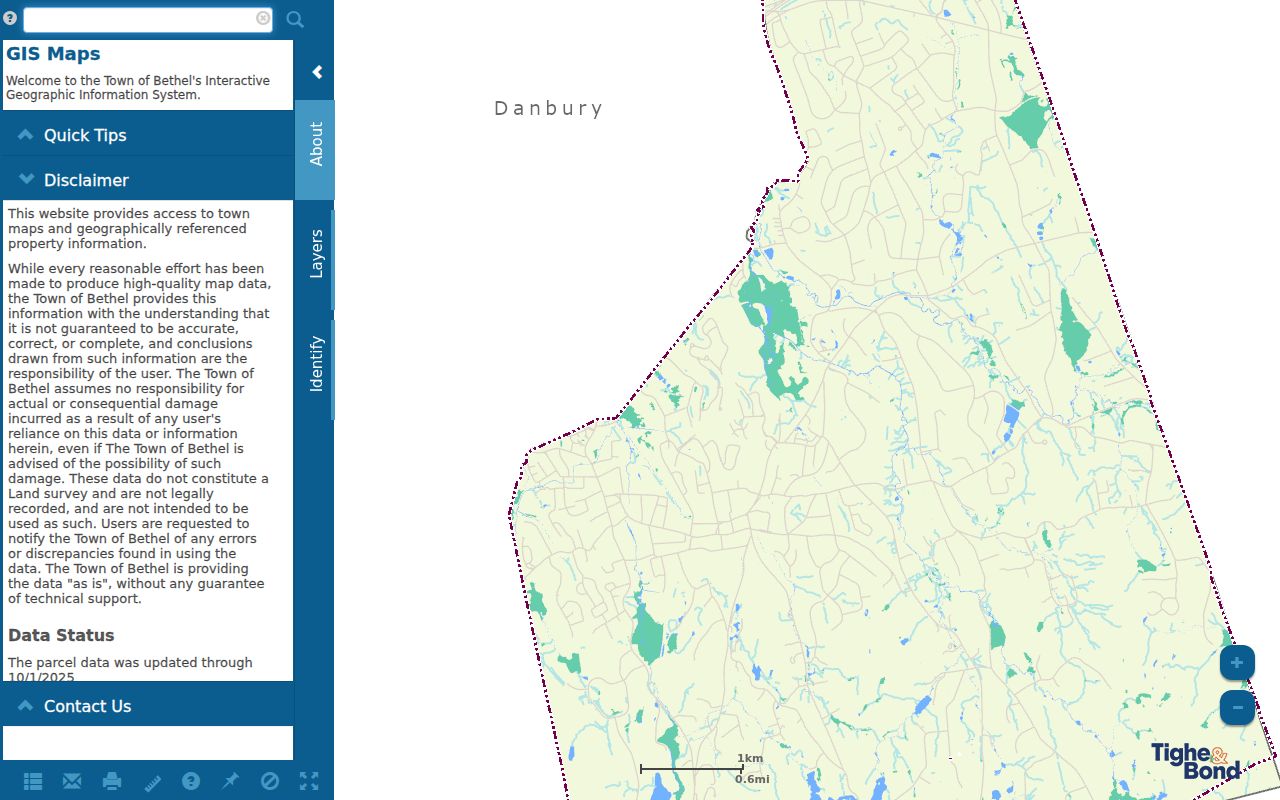
Date the result. The Town describes parcel data as of 11/1/2024 and ownership data as of 10/1/2024. Aerial layers from 2012, 2016, 2019, and 2023 help with lot shape and road context, but imagery is not title evidence or a survey.
Bethel Neighbors: Owner, Mailing, Occupant
Owner, mailing, and occupant are three different ideas. A situs address identifies the parcel’s physical location. A mailing address is where tax or assessment notices go, which may be the parcel, another address, a trustee, an LLC, or a service address. The owner line is a record label, not a count of people inside. The IAS card can also show a deed volume and page, sales rows, valuation, permits, and building facts. Use those fields to choose the next record, not to announce a household.
The Bethel GIS REST parcel query exposes a dated machine-readable sample. Its fields include Parcel ID, Feature Type, Address, Owner, Mailing Address, Book, Page, Sale Date, and Sale Price.
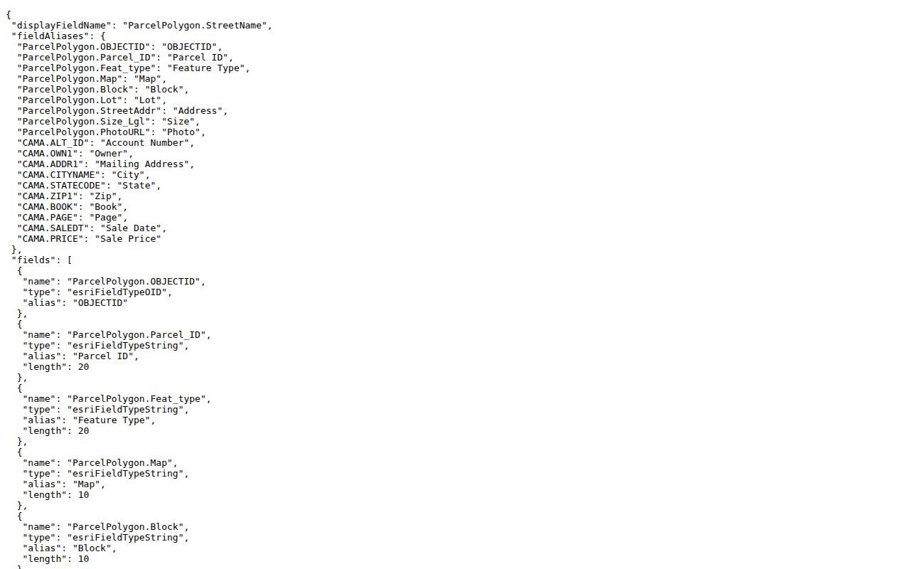
In the sample, Parcel 57 115 01A is a PARCEL on Research Drive, owned by Berkshire North LLC, with mailing address 2 Parklawn Drive, Bethel, CT 06801, and Book/Page 645/618. Sale date and price are blank. Blank fields stay blank; they do not prove that no sale occurred.
Bethel Parcel Types Around a Block
An adjacent polygon is not automatically a residence. The REST layer’s Feature Type domain can mark a record as Parcel, Condo, Right-of-way, Water, Cemetery, Portion extends beyond town boundary, or Main parcel of condominium complex. Check that field before calling a shape a neighboring property. A right-of-way may touch a lot without having an owner in the same sense; water or cemetery parcels should not be counted as household locations.
Use the civic layer as a second check. The official Bethel street guide maps side and number ranges to districts and polling places, but it does not list voter names or ballot choices. Rockwell Road crosses four voting districts; Walnut Hill Road reaches Districts 1, 2, and 4; Chestnut Street splits odd and even ranges between Districts 1 and 3. This is a geographic crosswalk for a block, not a voter directory. It can flag a bad number or spelling before a parcel search is treated as a match.
Bethel Neighbors in Planning Files
Public files tied to a nearby address can explain a block without identifying a household. Bethel Planning & Zoning posts address-indexed applications, plans, comments, decisions, and neighboring-property-owner notices. The 48/50 Nashville Road page records an application denied on 10/14/2025; the 72 Reservoir Street page shows an approval with supporting documents. These are property and process records. They are not proof that a noticed owner lives next door.
Building Documents points to CitySquared and lists plan review, residential and commercial applications, inspections, demolition, pools, and related checklists. Public 2025 permit reports and 2026 monthly reports can supply an issue date, permit type, or address lead. Health forms can contain property owner, address, water/sewer, plan, and service fields. An alarm form includes owner, address, and keyholder fields, but public access and retention were not located. Do not copy keyholder details.
For an older block, remember that Bethel separated from Danbury in 1855. Pre-separation records may use Danbury, and the 1777 loss of Danbury records can leave an indirect trail through maps, directories, newspapers, or later deeds.
Bethel Civic Contacts for a Block
Community contacts can answer a neighbor question at the organization level. They should not be turned into a member or home-address list. Bethel’s research sources point to a library, historical society, Chamber, and town civic records, while no official comprehensive directory of neighborhood associations or HOAs was located. Ask an organization for a public email, meeting page, or office contact only; do not infer membership from a parcel owner.
| Resource | Useful Community Context | Public Route and Boundary |
|---|---|---|
| Bethel Public Library | CTDA materials, local papers, photographs, and Adult Services referrals. | Public institution; no member or household roster located. |
| Bethel Historical Society | Historic streets, buildings, photographs, maps, and local-history contacts. | Public organization contact; no member roster located. |
| Bethel Chamber of Commerce | Business and community umbrella for public organization leads. | Membership is not verified as a resident or neighborhood directory. |
| Town Clerk and civic records | Official meeting, appointment, land-record, and municipal contact routes. | Not a neighborhood-membership list; ask for the exact record. |
| HOAs and neighborhood associations | Possible organization-level contacts or block notices. | No official comprehensive Bethel directory was located; do not infer membership from ownership. |
The Bethel Chamber of Commerce is shown as a community and business umbrella, not a resident source. The library’s Adult Services and CTDA access can fill older block gaps, while the Historical Society can help with streets, buildings, and local records.
The linked Chamber page is a public contact lead for Bethel civic organizations. It does not establish that a member lives at a particular parcel.
Use organization-level contact details only. A public phone, email, meeting notice, or office address is different from a private member or home-address roster.
Bethel Neighbors vs Commercial Tools
Official records and commercial neighbor-lookup categories may both return names or addresses, but they carry different weight. The official side has a custodian, a record date, and a stated field set. A commercial service may combine public parcel, postal, directory, and self-reported data; coverage, freshness, correction, and opt-out handling vary. Treat a match as a lead until it agrees with the source that created the record.
| Category | Best Use | What It Cannot Prove |
|---|---|---|
| Official Bethel sources | GIS, IAS, Town Clerk, street guide, SOTS, library, and planning records with a named route. | A current occupant, complete household, or safe reason to contact a person. |
| Commercial neighbor-lookup category | Convenience lead when a searcher needs another possible spelling or address clue. | Source date, accuracy, current presence, correction history, or lawful use of a result. |
An owner name repeated across GIS and IAS is still an owner snapshot, not an invitation to contact someone. A directory entry is historical, and a civic contact is organization-level. Keep the source URL, inspection date, and field label beside each result, and remove phone, email, date-of-birth, or family details that are not needed.
Protecting Bethel Addresses and Abutters
Some Bethel residents are intentionally absent from public results. Connecticut’s Address Confidentiality Program/Safe at Home gives qualifying participants a substitute mailing address; the Voter Privacy Program can suppress a qualifying person’s voter name and address. CGS §1-217 lets listed protected officials and workers request residential-address nondisclosure from specified records. These protections do not erase every deed, GIS row, grand-list field, or town record, so ask the custodian what rule applies rather than trying to reverse a substitute address.
Other limits are just as important. DMV address data is controlled by the federal DPPA and Connecticut law. Utility and delivery customer lists are not an ordinary public municipal lookup. Alarm keyholder details, victim data, sealed or restricted court files, juvenile material, adoption records, and protected vital-record fields should not be copied into a neighbor profile. A public land record can be stale or about a different person with the same name. Cite the source and date, use the minimum needed fields, and stop when the evidence stops.
Connecticut Freedom of Information Act access does not override a confidentiality statute or turn a request into a right to publish a contact list. A request may be written or oral, but the custodian still controls exempt, sealed, investigative, medical, juvenile, and victim material. Verify deed-copy demands, revaluation calls, court notices, or voter-file offers on the official town or state site before sending money or identity documents.
Lawful use. Bethel neighbor research is appropriate for civic context, family history, reconnecting, or a careful property-record question. Do not use an address to stalk, harass, threaten, expose, or monitor a person. Connecticut’s harassment and stalking laws apply to misuse of address data.