
Bethel Previous Residents: Era Sources
Past residents of a Bethel address leave different traces. A deed can show a transfer, a directory can show a listed household, a census can show people counted together, and a permit can date work at the property. The coverage table keeps those questions apart and marks the gaps that affect a house-history search.
| Source | Years It Covers | Where Held | What It Shows |
|---|---|---|---|
| Bethel land records | 1855-today; online cutoff not located | Town Clerk counter and SearchIQS | Deeds, mortgages, releases, easements, liens, maps, and recorded party chain |
| IAS assessor field cards | Current card; 2022 revaluation cycle | Bethel Assessor and IAS | Owner snapshot, mailing and situs lines, Book/Page, sales, building facts, permits, and valuation |
| Bethel GIS parcel layer | Parcel data 11/1/2024; ownership 10/1/2024 | Tighe & Bond viewer and REST service | Parcel identity, owner, mailing address, Book/Page, maps, aerials, and abutters |
| City directories | ACPL lead 1913-1935; Price & Lee 1918; NARA 1927-1932; 1936 and licensed 1948-55/later leads | Library, NARA, FamilySearch, and licensed collections | Publication-era names, addresses, household markers, and business or occupation clues |
| Federal census | 1790-1950 generally public under the 72-year rule | NARA, FamilySearch, and library databases | Household members, age, relationship, and enumeration-area context |
| Sanborn fire-insurance map | Bethel sheet 1889 | Library of Congress and Connecticut History leads | Building footprint, use, and street context, not an occupant list |
| Newspapers and cemetery sources | 1874-1896 papers; Home News obituaries 1966-1967; Hale copy 1934 | Connecticut State Library, Bethel Library, and Hale collection | Moves, deaths, notices, burial names, and location clues |
| Building and land-use files | 2025 annual permits and 2026 monthly reports; older span not located | Bethel Building, CitySquared, Planning and Zoning | Permit, plan, application, inspection, neighbor-notice, and decision dates |
Start with the source that matches the question. Use the IAS card and GIS for a modern parcel anchor, the Town Clerk for title evidence, directories and census schedules for household history, and newspapers, cemeteries, probate, or permits to test a move or ending. No single row proves every person who lived at an address.
Bethel Previous Residents: Whippoorwill Card
The Bethel Assessor and its IAS field-card search give a concrete starting point for past residents. Search controls include Parcel ID, Alternate ID, Owner 1 Name, Street Number, and Street Name. The public sample is Parcel 32 47 083, Alternate ID R01740, Card 1, at 31 Whippoorwill Road, Bethel, CT 06801.
The sample lists zoning R-20, single-family land use, 0.46 acres, and owner line HUGHES CHRISTOPHER & NASH LAURA. Its mailing line matches the situs address. The deed pointer is Volume 1147, Page 826. Sales lines show 09/14/2021 at $408,500 and 11/03/2008 at $325,000. A 01/01/1800 line is blank and legacy, not an actual sale date.
The IAS parcel card for 31 Whippoorwill Road is useful because it joins a person name, address, parcel, Book/Page, sales, building facts, and valuation in one record. It remains an assessor snapshot. It is not a certified deed, title opinion, occupancy confirmation, or guarantee that the named owners still live at the property.
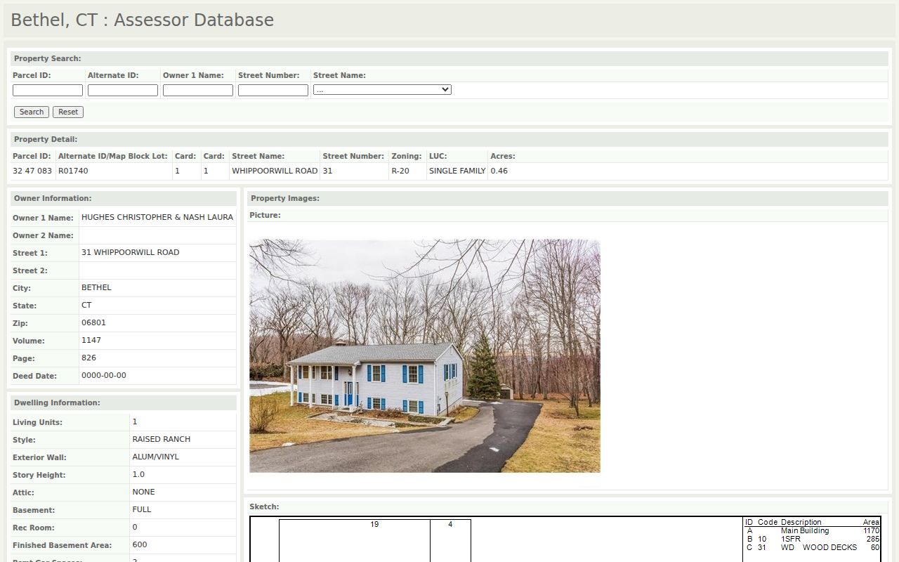
The image is the parcel anchor for a backward search. Preserve the card date, card number, owner spelling, alternate ID, Book/Page, and every blank field before moving to the Town Clerk record.
Read Bethel Past Residents' Sales History
Sales rows help locate a deed, but they do not carry the same weight as the recorded instrument. The 31 Whippoorwill card's 2021 and 2008 lines are leads to Book/Page 1147/826 and 964/477. The blank legacy row should stay blank. A missing price or placeholder date does not prove that no transfer occurred.
| Owner line | Names the assessor's current owner field, which may be abbreviated, trust-held, entity-held, or stale after a recent recording. |
|---|---|
| Mailing line | Shows where assessment correspondence goes. It may match the property address or point elsewhere, and it does not prove occupancy. |
| Book and Page | Provides a cross-portal pointer to the Town Clerk land-record index, not the certified document itself. |
| Sale date and price | Records the card's sales history row. Treat the 09/14/2021 $408,500 and 11/03/2008 $325,000 entries as dated leads. |
| Legacy 01/01/1800 row | The sample shows a blank value beside the date. Keep it as a legacy field and do not turn it into an eighteenth-century conveyance. |
| Valuation cycle | Bethel's last completed revaluation was 2022. A card should be dated before comparing its assessment with a later record. |
The Town's revaluation material points to a 2027 fair-market date and a new grand-list cycle. That makes the assessment date part of the evidence label. Past-resident research should compare like with like: a 2022 card, a 2024 GIS snapshot, and a recorded deed are separate clocks.
Snapshot rule. Use IAS to find the parcel and deed pointer, then verify ownership and transfer details with the Town Clerk. Do not turn a field-card owner into a claim about who lives there.
Trace Bethel Address Records Backward
Connecticut has no county recorder for Bethel land records. The Bethel Town Clerk holds local land records, surveys, and maps from 1855 to today. Use the Town Clerk for the counter route and the SearchIQS Bethel portal for the guest, account, subscription, payment, and image route. The authenticated grantor and grantee result grid was not exposed in the research session, and the online start year was not located in an official source.
- Start with the IAS owner, parcel or alternate ID, situs and mailing lines, and Book/Page. Copy the legal owner name exactly, including a trust or entity form.
- Search the current purchase in SearchIQS by party name and confirm instrument type, recording date, Book/Page, address or legal description, and image availability.
- Take the seller shown as grantor and search that name as a prior grantee. Keep the same legal description, map, lot, block, subdivision, and nearby road in the search.
- Repeat backward through deeds, then check related mortgages, releases, assignments, easements, liens, and maps. A street number can change while the legal description stays useful.
- When the online boundary or image access stops, use the Town Clerk counter, deed books, certified copies, microfilm, State Library or archival referrals. Do not invent an oldest online year.
- Grantor
- The party transferring an interest in the recorded instrument.
- Grantee
- The party receiving that interest. In a backward chain, yesterday's grantor becomes a prior grantee to search.
- Chain of title
- The linked sequence of recorded transfers that connects one owner interest to earlier instruments.
- Legal description
- The recorded land description, often using map, lot, block, subdivision, or metes-and-bounds language, that can outlast a postal address.
Bethel's fee routes also differ. In-person copies are listed at $1 per page. The current standard recording fee effective July 1, 2025 is $70 for the first page and $5 for each additional page. SearchIQS portal images may carry account or image charges, and portal copies are not official copies. Request a certified copy from the Town Clerk when proof matters.
Bethel Previous Residents and 1855
Bethel separated from Danbury in 1855. The Town Clerk's current custody statement begins local land records at that break, so a deed or directory search for an older address may use Danbury, an older street label, or an ecclesiastical setting instead of modern Bethel wording.
The 1777 British raid that burned Danbury's courthouse and city records adds a second complication. Early previous residents may need cemetery inscriptions, family papers, newspapers, later reconstructions, or a local history item rather than a clean deed run. Treat the absence of an early index as a historical finding, not proof that no household or transfer existed.
Keep jurisdiction and source type in the citation. A post-1855 Town Clerk instrument, a Danbury-era regional directory, and a later assessor card can all refer to one place while describing different legal and publication contexts.
Bethel Past Residents: Maps and Gaps
The Connecticut State Library house-history guide recommends joining maps, deeds, directories, newspapers, and local collections when an address changes. Bethel's 1889 Sanborn sheet is a building-context source. It can show footprint, use, and street setting, but it is not an occupant list. The failed manifest capture for the Library of Congress Sanborn image means the source is linked in prose only, with no unavailable image added here.
The guide image belongs before the map and deed crosswalk. Use the current street number as a search term, then test the older spelling, nearby road, subdivision, map, lot, and block. The exact year-by-year Bethel street-renumbering and renaming chronology was not located, so a number match alone is not enough.
Historical Society material adds an 1867 landowners map, the 1986 WPA survey, P.T. Barnum's Greenwood Avenue and Chestnut Street addresses, and the 137 Rockwell Road house-history lead. An assessor construction year and a map or deed date are different evidence. Keep the building story separate from a claim about a prior occupant.
Bethel Previous Residents in Directories
Ownership records do not answer who lived at an address. Bethel city directories, criss-cross sections, and federal census schedules add the household layer. The collection details belong to the Bethel city directory collections route, while the address trail below keeps the task focused on one place and one period.
- Choose a directory year near the address date. The strongest local lead is the 1918 Price & Lee Danbury and Bethel Directory, with ACPL's 1913-1935 lead and regional runs for later checks.
- Read the name, spouse or head, occupation, address, and marks such as
h,res,r, orbds. Preserve owner, renter, or boarder marks when a volume supplies them. - Pair 1918 with the 1920 census, 1927-1932 directory runs with 1930, 1936-1940 with 1940, and licensed 1947-1955 runs with 1950. Compare street, household members, and spelling.
- Use newspapers, the Bethel Home News obituary index, cemetery pages, and CTDA to test a move, death, or removal. A disappearance can also be an unlisted year or a missing volume.
- Label the result as a directory listing, census household, index lead, or verified record. None of these labels should be rewritten as current occupancy without a separate current source.
The phrase past residents is useful for the research question, but the evidence must stay date-bound. A 1918 address line can show where a person was listed in print; it cannot prove that the same person owned the parcel or remained there later.
Bethel Residents: Newspapers, Hale, Probate
When a household leaves a directory, a dated notice may explain why. State Library microfilm lists Bethel Press and Bethel Ledger for 1874-1883 and Bethel papers for 1881-1896. The Bethel Home News obituary index covers 1966-1967. Keep the title, date, reel or page, and image status with every citation.
| Newspaper | May record a move, death, legal notice, business change, or address without proving that every household member lived there. |
|---|---|
| Hale cemetery copy | Charles R. Hale's November 1934 Bethel material has inscriptions on pages 1-158, index pages 159-197, cemetery list page 198, and location chart page 199. |
| Probate PD-45 route | Connecticut's Probate case lookup can point to an estate, fiduciary, or property filing. A probate endpoint does not prove that every heir lived at the address. |
Use the State Library newspaper list, the Bethel Home News index, the Hale Bethel pages, and the Probate case lookup as separate trails. No official municipal interment database was located, so a library, caretaker, historical society, or paper volume may be needed.
Bethel Previous Residents: Permit Trails
Address-keyed permits can date work, applications, or inspections in a house history. Bethel Building Documents links to CitySquared and lists plan-review, residential and commercial applications, inspections, demolition, pool, and related forms. Public annual material includes a 2025 permit-type report and monthly 2026 reports, while older archive coverage was not located.
| 48/50 Nashville Road | The Planning and Zoning page shows an application denied 10/14/2025 with neighboring-property-owner, plan, comment, and decision material. |
|---|---|
| 72 Reservoir Street | The address page shows an approval pattern with supporting documents. The page is an application record, not a list of people living nearby. |
| Permit or plan date | Use the issue date, application, address, type, and status as an activity anchor. Do not turn work at a property into a transfer or occupancy conclusion. |
Compare a permit date with the IAS sales row, GIS data date, and deed recording date. Those dates can describe the same parcel without describing the same event. The purpose is to place a building change in time and then return to the recorded land record for title questions.
Bethel Previous Residents: Two Clocks
A good house history keeps a historical clock beside a modern records clock. The first clock follows directory publication, census enumeration, newspaper notice, map, cemetery, or permit dates. The second follows the data cycle or recording date carried by a current portal. Mixing them can make a 1918 listing look current or make a 2024 owner snapshot look historical.
| Historical clock | Modern records clock | How to use the pair |
|---|---|---|
| 1918 directory, 1920 census, 1934 Hale copy | IAS card and Book/Page pointer | Test a printed name against a parcel lead without calling it current |
| 1874-1896 newspaper dates and 1889 Sanborn context | GIS ownership 10/1/2024 and parcel data 11/1/2024 | Compare an older building or notice with a dated modern map snapshot |
| 1855 Bethel jurisdiction break and 1777 Danbury loss | Town Clerk custody 1855-today and SearchIQS access limits | Choose Danbury-era or counter/archive sources when the online chain ends |
For the Whippoorwill sample, the triad is IAS Parcel 32 47 083 and R01740, GIS or parcel dates, and the Town Clerk/SearchIQS deed result or explicit result gap. Preserve blank fields, source dates, and the distinction between index, image, snapshot, and certified copy.
Lawful house history. Previous-resident research in Bethel is suited to genealogy, house history, and personal record checking. Do not use an address finding to stalk, harass, threaten, monitor, or harm a living person. Safety programs and restricted records may make a responsible result intentionally incomplete.